
Why use your iPhone as Motorcycle GPS?

- It’s cheap! Regular Motorcycle GPS units will set you back as much as $500.
- It saves you carrying around a second device.
- It’s easier to find and load motorcycle tracks & routes.
These are very prominent advantages. Having said that, you’ll need to consider some things when choosing to use your Phone as Motorcycle Navigation. You can go the cheap way and put the phone in your pocket, but if you want to mount your device there are some more things to consider.
UPDATE Aug 2, 2016
My new app Scenic was released in the App Store just last week. It has full turn-by-turn and voice guidance, you can make any GPX navigable, create your own routes and track and documents your rides. Feedback of users has been awesome so far. Give it a try if you want. It’s free to download. https://itunes.apple.com/app/id1089668246 and here is a video of the app in action: https://youtu.be/rKavcXRm4P0
END UPDATE
iPhone as Motorcycle GPS – 8 things to consider
1. Mounting
First choice you have to make: Will you carry it in your pocket or attach it in a place where you can see (and possibly touch) the screen.
 Carrying your phone in your pocket is the cheapest and safest choice. You will not be tempted to look at (or touch) the screen. The disadvantage is that the use of your phone is very limited. Every time you want to look at your device you’ll have to find a safe place to stop, actually stop, take of your gloves, open your pocket, take out your phone and vice versa when you’re done. When the phone is in your pocket you can use Scenic to record your rides and add pictures and notes to them when you stop for a break. That way you’ll be able to keep a history of all your riding adventures and share it with friends. Because you can’t see the screen you will not be able to use Scenic as motorcycle navigation and follow a track.
 Seeing the screen has a distinct advantage. You don’t have to stop every time you want to see the screen. Because you can see your screen you can have helpfull apps open during your ride. For example Google Maps, Apple Maps or of course Scenic.
If you can see your Phone you can use Scenic maximum potential. In addition to recording your rides you can look at the map, select tracks, navigate them and easily control your music playback through the specialized “Glove” music controls.
2. Weather Protection
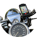
If you want to see (and touch) the screen of your phone you’ll have to attach it to your motorcycle somehow.
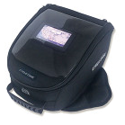 The most simple solution is putting your phone in your tank bag’s (see through) map holder. Disadvantages of this option is that most likely your touch screen will not work through the plastic of your tank bag. Furthermore your phone might move around in there and you’ll have to look down quite a bit to see what’s on the screen. Depending on where you live you might want weather protection for your Phone. Your phone in the tank bag map holder might not offer sufficient protection against heavy rain.
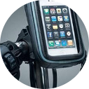 Nowadays more and more weather proof cases are out there. Most of them protect your phone from the elements while keeping the touch functionality. Some of them offer a range of mounts that enable you to put your Phone in a safe and visible place on your motorcycle like for example the handle bars. I’ve always been very happy with my lifeproof case and the also offer mounts.
For MotoMap it is best to have your Phone in a visible position. That way you can use it’s functionality to navigate tracks on the map.
3. Sound
For sound there are many options out there, varying in price and usability. Easiest option is to have no sound. For some this is the most pure way of motorcycle riding.
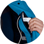
 Other people wear their phone’s default in-ear headset under their helmet. There are even people who put the cable remote in their mouth, operating it with their teeth or lips to control volume, answer calls, play and pause music, etc. This might work well for you. Also this is a relatively safe option because you don’t have to use your hands. The disadvantage of this option is that you still have a cable running from your phone to your ears. If your phone is in your jacket pocket this is not such a big deal, but if your phone is attached to your motorcycle make sure to disconnect the cable before you get of your motorcycle! Some people might find earplugs uncomfortable under a helmet for a longer period of time.
 On the other side are the (relatively expensive) Bluetooth enabled motorcycle headsets. There are many out there varying in price and quality. Some even have basic control buttons much like the cable remote on your in-ear headphones. You’ll probably have to use your hands though.
For Scenic you don’t necessary need sound, although Scenic does offer the option to play music in the background and it has some audio feedback.
4. Touch
Your phone’s screen can not be operated with standard (motorcycle) gloves. This is because it operates through the change in electrical current that occurs when a finger touches the screen. Materials that cannot conduct electricity, like used in motorcycle gloves, prevent the transmission of electricity to the screen.
 There are some manufacturers out there that offer special motorcycle gloves enabling the operation of touch screens. It’s also possible to “convert” your current gloves to enable touch operation of your phone. This requires a bit of conductive wire and some rough sowing techniques. For more information on this see this site.
Scenic is especially designed for use on your motorcycle, with gloves! The optional zoom buttons are extra large and there is an easy way to control your music with your left index finger only. It does require converting your gloves for touch operation.
If you are willing to spend the extra bucks, there are alternatives to this like mentioned here. Unfortunately this kickstarter project that we posted about on our social pages didn’t make it.
UPDATE: There’s also a new product out there that lets you convert your normal gloves to touch enabled gloves.
5. Battery Consumption
Apps that use your phone’s GPS receiver use a lot of battery. Scenic is no exception. That’s why it’s recommended to have your phone connected to a charger.
 You can use any kind of car charger for this, but there are also motorcycle specific solutions out there. Some motorcycles have a “cigarette lighter” outlet by default. If your motorcycle doesn’t have one it’s relatively easy to install a (universal) one afterwards. These universal cigarette lighter outlets are readily available from online stores. Make sure you choose one that offers sufficient weather protection. Also you can choose to install a USB Socket where you can plug in your phone’s regular USB cable. These are also available from many on-line stores.
When you have to buy a charger and socket, it is recommended to buy one that can provide 2 amps of current to your device. Especially the newer phones (from iPhone 5 onwards) use a lot of power. 1 amp chargers will work, but because your phone is probably using GPS and full brightness continuously it needs a lot of power. I also HIGHLY RECOMMEND to buy an Apple Approved charger. I’ve had several Scenic users now reporting a drop in battery charge, while connected to a charger. It turned out they were using cheap ‘chinese’ chargers and when they replaced it with a good one the problem was gone.
6. Screen visibility
Sunny weather is nice for riding, however the visibility of your screen can be limited because of it.
 When positioning your device on your motorcycle make sure that the sun and daylight is not reflected from the screen into your eyes. With a lot of sun you might want to set the brightness of your screen to full, although your phone will probably do that automatically already.
7. Overheating & Vibrations
 When using your iPhone intensively, in direct sunlight, without sufficient airflow to get rid of the heat, it is possible that your iPhone overheats. This results in a warning message on your screen and your open apps to stop until your iPhone is cooled, effectively rendering your iPhone useless for a period that usually lasts about 15 minutes.
This happened to me only once, when the iPhone was in the plastic cover of my tank bag with full sun and running two GPS apps in the background. Typically the tank bag see trough plastic ‘map holder’ covers are notorious for this. There is not airflow and the plastic acts as a small ‘oven’ when in full sun. (Compare it to sitting in a parked car in full sun with all windows closed).
As for vibrations. I’ve had some questions about this. To be short, I’ve never had any problems with it, nor did I receive any reports about an iPhone being damaged because of vibrations on the motorcycle.
An important factor for overheating (and possible vibration) will be the case that you use. The casing should allow enough cooling and be “ruggedized” (which most weather proof cases are). With my lifeproof case I never had any problems.
8. Motorcycle GPS App
Finally, when you have the hardware figured out, you’re gonna need a GPS Navigation app that’s usable for Motorcycle Riding. Some are more suited than others so it’s important to choose the right one for you. I wrote 2 review and comparison articles on Motorcycle/Navigation apps. The first one focusses on mainstream navigation apps and their use for MC riding, while the 2nd one focusses on apps specifically developed for Motorcycle Riding.
The End Result
Even with the costs of a phone mount, weather proof case and power supply you’ll still be out a lot cheaper compared to the motorcycle navigation devices out there. On top of that, you’ll have an enormous range of Motorcycle Apps and mainstream navigation apps to choose from and you can change between them without having to buy a new device. So, for me, this is a no brainer.
The above considerations have been compiled based on the experience of motorcycle friends and my own experience. I tried many different options discussed here (even owned a Garmin Zumo for a while) and in the end chose to sell it off. I now found the perfect setup for me, of course yours might be different.
I like the sound of this
3 questions
Which off line maps do you use ?
Worldwide & free for life ?
Most important, I want to make routes on my iPad and air drop to iPhone, phone on bars pad in tankbags. Change route lunch or make new wherever, offline.
So can I buy premium for 2 devises or gat had by apple with the in app purchase only on one thing ?
Thanks
1. Scenic uses offline maps based on Open Street Maps through a 3rd party map provider.
2. Not free, but you do get some free credits to get you started. More info here: http://www.motomappers.com/faqs/faqs.php#whyIAP
3a. Airdrop works but is a bit cumbersome as you have to export a route to gpx from one device, airdrop it to the other device and import it there. Better is to sync… as long as you logged in with same account in Scenic on both iPad and iPhone (and both have an internet connection) any changes will sync between them instantly (pull-to-refresh).
3b. Changing route is possible or make a new one, but as mentioned above, if you are offline changes won’t sync between devices… you’ll need to do the changes on the iPhone… or do a new export, airdrop, import every time (which I don’t recommend when on the move)
3c. Before you do an In App Purchase, make sure you registered an email and password in Scenic (tap profile button in main screen and then first row). Then, any purchases you did will also sync between devices, so you only need to buy once.
Just give it a try… it’s free to download and you even get credits to try out the premium features. If you have any more questions… a lot of info is available on the support page, including tutorial videos: http://www.motomappers.com/faqs/faqs.php
Here’s the direct link to the app store: https://itunes.apple.com/app/id1089668246
Prob hard for you to get but here in Australia off line is most of time, internet only where people are, synching by internet ok at home but not on the road.
More importantly I travel in Europe every year and buying sims to work in different countries just a hassle I don’t need. Even uk sims don’t work in the Isle of Man !
I like your idea of own routes, Garmin etc cannot understand no motorway doesn’t mean I want to go through centre of Paris.
So planning on iPad with offline maps and airdrop to phone on bars is perfect for me.
Shame it’s hassle but much less so than changing cards in Garmin, even then the thing changes routes at will, they don’t believe I want to go my way.
Thanks for tip re registering address first, I bought Sygic and even though they say it will work on all devices , it doesn’t.
Surely just buying it should register with you, why make it complicated ?
I will try but not keen on buying osm maps, I have osm maps on my computer and are totally free on net, I would much rather pay more for app and be able to use any maps.
As you know some maps are better than others, google, Sygic etc etc love white roads on grey background, nearly invisible outside. I need clarity.
Guess I’m the odd one,
I understand where you are coming from. As said, airdropping is possible, but I really recommend to directly change on the iPhone. It will save you a lot of time and it’s pretty easy to do this even on the small screen.
There’s a difference in In App Purchases kinds. The yearly subscription registeres with Apple and Apple ‘remembers’ that… so you can get ‘restore’ it on another device without creating a Scenic account. The premium forever and the credits are one time purchases and are not ‘remembered’ by Apple. They will only sync if you register a Scenic account with email. I recommend to do this anyway to sync your own data (vehicles, routes, trips, etc) between your devices so you won’t have to enter it twice on every device. We do not spam. You’ll get one or two emails a year, besides a verification email and possible password reset email if you forget your password.
The OSM maps are enriched with own data of the 3rd party map provider. Sothey are not OSM maps as such… the maps are based on OSM data, but are transformed into a different proprietary format of the 3rd party map provider and enriched with their own data in the proces. No doubt Google, TomTom, Garmin and Sygic maps are more complete. The style of the maps however has nothing to do with the source of the map data. Scenic offers 3 different map styles and 1 night style.
Hope this explains a bit more.
Thanks, easy to do on small screen isn’t same when you’re nearly sixty with fat fingers that hit everything except that intersection. Zooming in and out frustrates me. I’ll see if I can master the export import thing. Odd really cos Sygic it’s a simple send route.
I’m actually not just doing this for myself. Some friends run a motorcycle tour business and they really want to be able to give customers the day, of course things change (as they should on any adventure) To make a new plan and airdrop to all— totally brilliant.
To get each to create the new route a mad can of worms.
Pretty sure there’s plenty of others in same boat, the days of handing out sd cards for Garmin are over. Bluetooth or Airdrop have to be the way. Once route is created a one touch send should be easy. Email or airdrop is same procedure, people want to share days route, not always same account, but they need to have your app.
Make that feature cost a few bucks, see if I’m right
ok
i like the app, easy to create route, many vias is the trick
Now I didn’t find airdrop tricky at all, save route and send
but when my iphone receives file it wants me to get pocket earth from app store, anyway of getting the iphone to know it is a scenic file ?
if that can be done, Im happy, route on ipad, look at iphone
Hi Martin,
I have to look into this in more detail. It used to work with previous iOS versions. I’ll get back to you on this by the end of the week. Sorry for the inconvenience.
Since writing this I tried it the other way, from iphone to ipad, works easily, prob much easier than using net as middle man. But cannot seem to make it work ipad to iphone, obviously the way I need it to work. Concept is all there, just need to solve the execution. Both are on latest software update so a bit confusing, trying the turn them both completely off trick next. Often the essiest fix.
Only other thing that would be handy is adding vias without having to click prior via. As it is building route without destination seems quickest, vias after every junction
Saw the ipad export update, installed it on pad and phone
Problem still there
Is not ipad failing to export is ios wanting to open file in another app
Takes me to app store many choices but no scenic
Tried a few tricks like finding scenic in app store then hitting open no go
Message on ipad says declined
As I understand it ios needs to know it is file scenic
Please test and fix, this is exactly what is needed, airdropping routes would be sensational,
Other than that only map colours need fixing, Australia map shows white roads barely visible till you zoom close, dark colour showing all roads at any zoom and you have it craked.
Routing is brilliant
This is a different issue. This is a bug (or feature?) in the Apple Universal links and opening of files.
– When Scenic opens through a universal link the status bar will display the domain of that universal link in the top right of the status bar. In scenic’s case scenicapp.space.
– If you tap on that omce, the iOS device thinks that from now on ALL universal links and all files for this app should NOT open the App anymore, but in stead go to scenicapp.space, which, for Scenic, results in the App Store Scenic page opening.
-To resolve this, email the following link to yourself https://scenicapp.space/api/openScenic.php and open that email on your iPhone/iPad and ‘tap and hold’ on this link. An action sheet will appear where you should choose ‘Open in Scenic’. From then on all links and files will open in Scenic again.
Thanks but that did not fix
In my attempts yesterday i worked round it by sending file to memory map app on ipad then airdopping to mm on phone, sending to scenic.
This worked but very long winded.
Now even after clicking link open in scenic when i airdop scenic file it opens in mm
So marginal gain
Tried deleting mm on phone
Clicked link repeatedly turned phone off on a few times
Back to app store message
I do understand, if it was on a mac desktop would be easy but iphone has it’s own mind.
Any other way to convince it
Ok plot thickens and managed to fool it by sending link different way
But now scenic on phone opens takes another credit then says
Import aborted
Not formatted correctly
ETC ETC
With element unknown
OK
Cannot see answer in faqs
We’re nearly there but credits fading, will buy as soon as this resolved
Any way of getting roads clearer on map ?
Hi Martin,
Can you send me the file or link you are trying to import (through email button under Contact section in ‘Support’ Page)? Also mention your Scenic Nickname (will give you back some credits).
For the road colors: can’t change them easily, but perhaps one of the other map styles (available from Settings -> Map) might work for you?
Hi Guido,
I was on a tour the last few days and when I opened Scenic to start navigating, I got a message saying that my maps needed to be updated. Fine, maybe when I get home, but for now (then) can I use the outdated stuff? No! Good thing I brought along my old Garmin, just forgot to bring the right charging wire for it….Is there a way that people can have a fallback when this happens?
Can you contact me trough the support link in the app or on motomappers.com please? You should have been able to continue using the old map so want to find out what went wrong. Tx
Gloves: my iphone 7 works just fine with my gloves. On my iphone 5S, I had to lick the tip of my finger to get it to work on the screen. I’ve also heard that pushing a small square of aluminum foil into the end of the glove finger works.
Weather protection: If I get caught in the rain, I put a small plastic shower cap (the freebies in hotel rooms) over the phone. Works great.
Audio: I’m using one of the cheap ($50) bluetooth helmet kits on Amazon. Seems to work fine.
Vibration: I have an iPhone 7. After using it on my Moto Guzzi Stelvio to navigate, the camera startet to swim, when taking a movie. The phone was mounted on the handle bar with a socket. This happend twince ( free Apple repair). Since the second repair I’m using an old IPhone 6 for navigation, which doesn’t have this problem.