
In this article we review the most popular, well known and, arguably, best GPS motorcycle navigation apps for usability with motorcycle riding. We focuss on useful features for motorcycle riders like scenic route planning and track importing.
UPDATE Feb 25, 2017
For a review of motorcycle specific apps for iPhone check out Best Motorcycle Navigation Apps for navigation and Tracking on iPhone – 2017 edition
END UPDATE
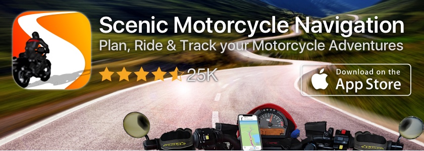
To be as unbiased as possible we did not include our own app Scenic in this comparison. We’ll leave it up to you to decide on that one.
Most of these apps require you to see the screen, while others you can use in your pocket. If you need (or want) to see the screen you’ll probably need a weatherproof case and mount. I’ve always been very happy with my lifeproof cases and mounts, but there are other options out there.
The apps reviewed are
- Google Maps (by Google)
- Maps (by Apple)
- Motion X GPS Drive (by MotionX)
- Waze (by Waze)
- Motion X GPS (by MotionX)
- Scout GPS (by Telenav)
- GPS Navigation by Scout (by Skobbler)
- MapQuest (by AOL)
- TomTom (by TomTom)
- Garmin (by Garmin) (a.k.a. Garmin Streetpilot Onboard)
- Sygic (by Sygic)
- CoPilot (by ALK Technologies)
- Navigon (by Garmin Wuerzburg)
Motorcycle riding is not about getting from A to B the fastest. It’s about adventure, freedom, the open road, curves, bends, scenery and many more things. That’s why motorcycle riders need more than point to point GPS navigation. We want scenic routes from A to B. We want real motorcycle navigation apps, to be able to import and follow tracks and routes, we want handsfree enabling us to keep our hands on the handlebars and we want directions to be clear in one quick glance so that we’re not distracted, can be safe and enjoy our rides more.
In this article we will not rate the apps against general usability, map quality, user interface, search quality etc. If you are interested in that we would like to refer you to one of the other “mainstream” comparisons, reviews and app shoot-outs out there.
Features Compared
- Scenic route planning abilities
- Ability to choose, import and follow tracks and routes
- Limits on number of route-/track points
- Automatic zoom
- Offline maps capability
- Price
Google Maps (by Google)
Google Maps is probably the most used navigation app. It’s great at guiding you from point A to point B. No further explanation required there. It’s not the best motorcycle navigation app though. It doesn’t have a scenic route option, you can’t import routes and maps are not really offline.
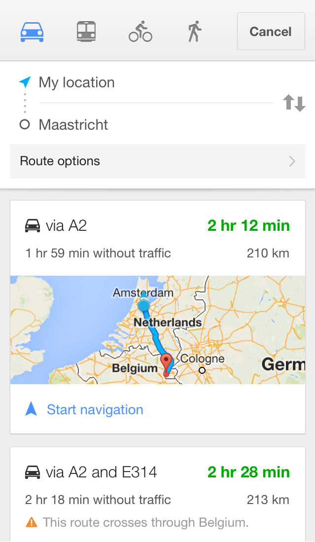 There are some basic route options (avoid highways, avoid tolls, avoid ferries), but that’s not exactly what you’re looking for as a motorcycle rider. Through maps.google.com it’s possible to create a route by adding additional destinations, however in the app this is not possible at the moment. Although google maps is not offline, it does cache map segments for the route that you’ve planned, which gives you limited off line use, but if you deviate from that route in a no coverage area you’ll find yourself with only a blue blinking dot on a grey background.
Maps (by Apple)
Like Google Maps, Maps by Apple is a great point to point navigation app (although opinions vary). Like Google Maps, it’s not really fit for motorcycle riding. It more or less has the same functionalities as Google Maps.
 Unlike google maps, it has no options to avoid highways, tollroads and ferries. The rest is quite similar from functionality perspective. Usability is a matter of opinion and taste. Some prefer Google Maps, others prefer Apple Maps.
Motion X GPS Drive (by MotionX)
 GPS Drive is a full blown navigation app. It offers turn by turn navigation for North America (US & Canada). It has all the features you can think of as a car driver.
 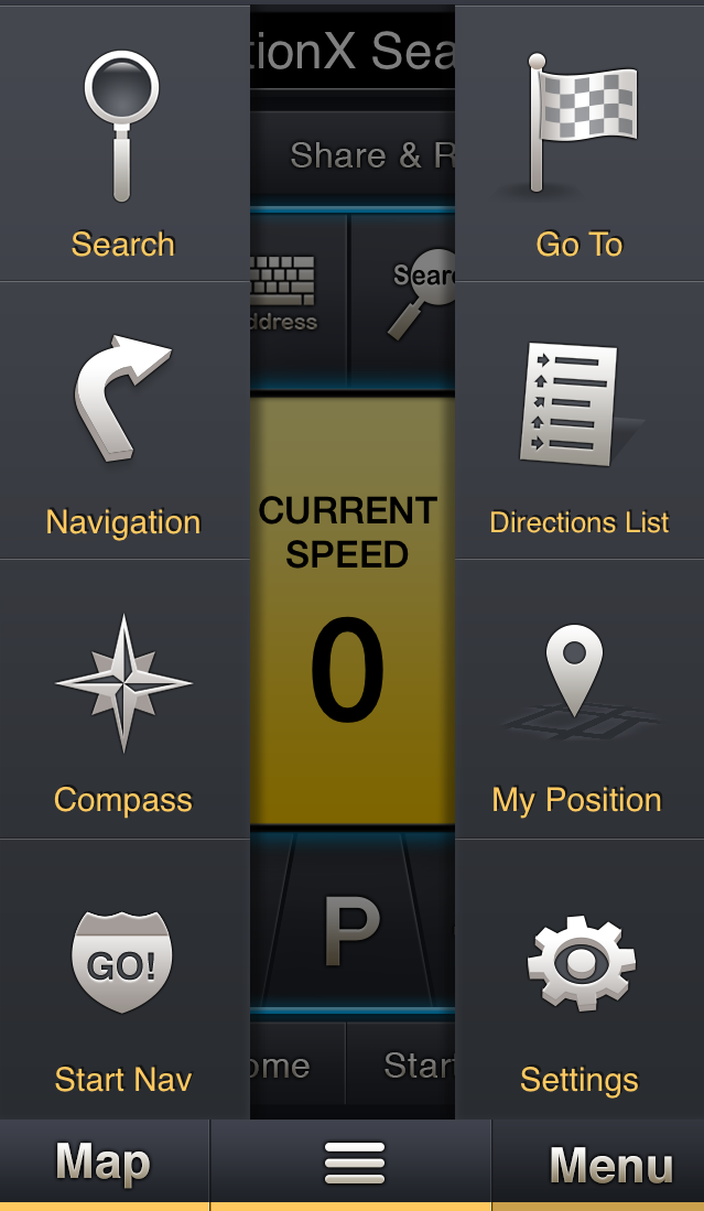 The menu design is quite unique to Motion X and takes some getting used to. When reviewing it against our motorcycle criteria it’s better than Google Maps and Apple Maps, but it’s not the best motorcycle navigation app.
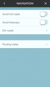
Although you can not import routes or tracks from a file, it is possible to add a multiple stop route from within the app. After entering your final destination you get the option to add additional “stops” to your route. You can add a maximum of 10 stops (including final destination) to your route.
You can’t import routes and it doesn’t have a scenic route option, but it does offer “fastest route” and “shortest route” and gives the option to avoid freeways, toll roads and unpaved roads.
Waze (by Waze)
 Waze is known as the social navigation app. The maps are constantly updated and maintained by the users driving around and giving updates.
 For motorcycle riding, measuring against our criteria, Waze is quite limited and comparable to google maps and apple maps with one (very small) plus point: it is possible to add an extra stop to your route. This is maximized by one point only though, making the maximum number of route points 2.
Importation of routes is not possible and as navigation options Waze offers quite similar settings as GPS Drive: avoid toll roads, avoid freeways and avoid (long) dirt roads. As routing styles two options are available: fastest and shortest.
Motion X GPS (by MotionX)
 GPS by MotionX (not to be confused with GPS Drive, also by MotionX) is a different kind of app compared to the ones discussed here. It’s not a navigation app with turn by turn directions and voice navigation. It targets out-door sports like hiking, mountain biking, skiing etc. and therefore can not be considered a real motorcycle navigation app.
 However it offers some distinct features that are useful for motorcycle riding. It’s possible to import routes through GPX files by opening them in another application (like mail or dropbox) and from there choose to open them in MotionX GPS. This will import the tracks and waypoints from the GPX file.
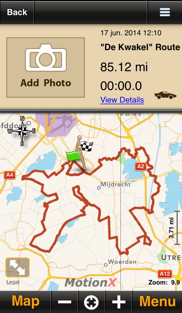
Once a track is imported you’ll be able to follow it with MotionX. It will display the track on a map keeping your current position centered. The map will not zoom in or out depending on your speed though. You’ll have to manually adjust zoom levels while on the move. For motorcycle riding this is not ideal as, unlike outdoor sports, our speed can vary quite a bit and we often wear gloves making screen operation impossible.
For the rest MotionX GPS is full of features. You have the ability to track and record your ride, it offers all kinds of maps and you can cache map regions upfront by selecting and downloading areas, making offline use possible. It’s quite impressive how much functionality they packed into this app.
Scout GPS (by Telenav)
 Scout is a navigation app currently covering the US only. From a standard functionality perspective it is quite similar to MotionX GPS Drive. It is a good navigation app for “normal” purposes, but, like MotionX GPS Drive, lacks some features for motorcycle riding.
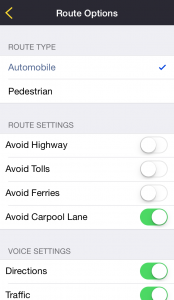 Importing routes or tracks is not possible and it currently doesn’t offer an option to add multiple destinations to your route. It does offer offline maps (in app purchase) for when you’re riding in a non-coverage area.
As routing options you can choose between automobile and pedestrian mode and you can choose to avoid highways, tolls, ferries and carpool lanes. A full scenic route options is not available.
GPS Navigation by Scout (by Skobbler)
 The name of this app might be a bit confusing looking at the previous app. That’s because this app has recently been added to Telenav’s global Scout product line. It’s still developed by Skobbler though and map coverage is almost worldwide.
 From a motorcycle perspective it offers pretty much the same functionality as scout. There is no import option and there is no option to add additional stops to your route. Route options are similar: avoid highways, tolls and ferries. For route profiles you can choose between shortest, fastest and most efficient. Additionally there are some bicycle routing options, but these are not really suitable for motorcycles as you can’t (well…are not allowed to) go on the bicycle path with your motorcycle.
MapQuest (by AOL)
 MapQuest is a nice navigation app. Next to the standard features provided by many other apps it offers route creation with up to 26 intermediate stops.
  From motorcycle navigation app perspective this is quite nice as this allows you to plan your route along these points. Unfortunately you can not pick these points from a map. You’ll have to enter them manually by typing an address or search term.
Currently it’s not possible to import routes into MapQuest, however on their website it appears that they are working on an URL/URI scheme which would enable other apps to open MapQuest with provided route-points. Until then it’s manual entry.
From a scenic route perspective MapQuest is no different than the apps already discussed. They offer avoidance of highways, tolls, ferries and unpaved roads. On top of that you can avoid seasonally closed roads and country border crossings.
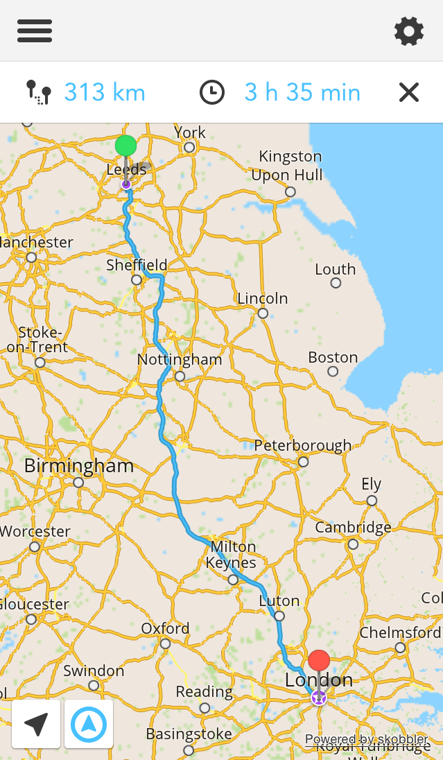
TomTom (by TomTom)
 Everybody knows TomTom from their satellite navigation devices. Also within the motorcycle community they are one of the few (together with Garmin) that offer a specialized sat nav device for Motorcycle Riders: TomTom Rider. A couple of years ago they started bringing out apps for mobile devices too.
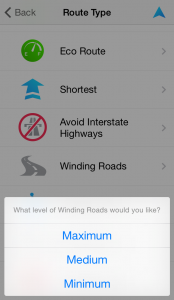 The TomTom app is a very complete navigation app and offers quite some features for motorcycle riders. They have a scenic routing option which they call “Winding Roads”. When choosing this option you can choose between the level of winding roads that you like: minimum, medium and maximum. You have to remember that TomTom does not know what is a good motorcycle road and what is not, but it can see (calculate) the winding level of roads and based on that propose a route.
In our tests this worked pretty good. It the city with lots of roads and traffic lights the Maximum setting appears to be the best for getting the nicest roads. In the country side medium or even minimum turned out to be the best setting. We recommend to preview your route before starting your ride and if you don’t like the calculated route you can always try a different setting.
Unfortunately it’s not possible to import a route into TomTom and for other apps to open TomTom with a complete itenerary. TomTom does allow you to plan a route upto a maximum of 7 points including start and end point, which is limited compared to MapQuest’s 26. The advantage over MapQuest is that you can select intermediate points by tapping on the map, which makes planning your route a bit easier.
Garmin (by Garmin)
 Like TomTom, Garmin is one of the few manufacturers that offers a weatherproof navigation device specifically designed for motorcycle riding. They have had several models over the years: Garmin Zumo 500, 550 and 660 and the latest models, the Garmin Zumo 340LM, 350LM, 390LM and 590LM.
Next to their devices Garmin started to offer navigation apps a few years ago. They were a bit late to the scene but eventually it seems they realized that a lot of people were looking for navigation on their phone.  The user interface of their apps looks a lot like the user interface on their devices, so if you used to own one of their devices that might work well for you.
From motorcycle navigation app perspective Garmin is nice too. Especially their trip planner is quite nice and works pretty good. You can select points from a map and you can save your trips. The number of destinations you can add seems unlimited, however if you add too many points you run into performance problems.
Garmin does offer some extensive routing options like “faster time”, “shorter distance”, “off-road” and avoidance of U-turns, highways, toll roads, traffic, ferries, carpool lanes and unpaved roads.
Sygic (by Sygic)
 Sygic is a very nice looking navigation app. Next to that it offers some features that are interesting for motorcycle riders. It doesn’t offer a scenic routing mode and it’s not possible to import routes. However Sygic made an URL scheme available to other apps that enables other apps to open Sygic with a pré-defined route. We are currently not aware of any motorcycle route apps that implemented this though. If you know of one, please leave a comment. We and all other readers would love to hear about it.
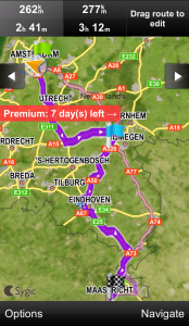 Sygics in-app route planner is very handy for motorcycle riders. You can add “via points” in various ways, but what’s really nice is that you can add via points by dragging the route. Once you’ve finished your route you can save it for later use.
In theory the number of via points is unlimited, but when we tried this on an iPhone 5 we got an error around 20 points. Our guess is that calculating a route with many via points is quite a hit on performance of your iPhone and we hit a limit there. You might get better results on an iPhone 5S (or iPhone 6). We would love to learn your experience with this.
As routing options Sygic is pretty similar to the other mainstream apps discussed above. It doesn’t have a scenic routing mode, but you can choose between the fastest, shortest or most economical route and avoid highways, tolls, ferries and unpaved roads.
CoPilot (by ALK Technologies)
 CoPilot is a bit different looking, but in a good way. It has a very clean user interface. For motorcycle use it’s pretty comparable to most of the apps discussed, although it does have a nice route planning function. It’s similar to Sygics, but without the “drag route” option. It also has the ability to save routes that you planned so that you don’t have to enter it all again every time you want to ride the same route.
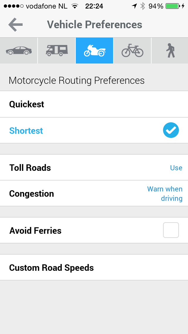 CoPilot does not have a “scenic” route option, but it does have Vehicle Preference, where you can select “motorcycle”. However when we tried this it gave us the same route as the car option. If you have a better experience with the Motorcycle Vehicle Preference please let us know.
Next to this CoPilot has pretty much the standard options: quickest, shortest and avoidance of toll roads and ferries. Strangely it doesn’t have an option to avoid highways.
Like almost all other apps in this review, CoPilot does not give the option to import routes through files. CoPilot, unlike Sygic, does not offer an URL scheme for other apps to open CoPilot with a route.
Navigon (by Garmin Wuerzburg)
 Navigon is one of the favorite motorcycle navigation apps in the community. It was one of the first to offer In App route creation with a significant number of routepoints. The current maximum number of routepoints is at 25 (including your startpoint). The route creation is not as handy as Sygics route dragging feature, but it does allow you to select a point on the map. You can also save your routes for future use.
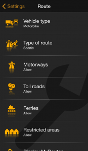
In addition you can choose “Motorcycle” as vehicle type and there is a “Scenic” routing option. In our tests we found this not as good as TomTom’s “Winding Roads” though. It does calculate a different route with this setting, away from the highways, but still it sends you along the bigger straight roads, while we know there are more motorcycle suitable roads for the destination we entered.
While following a route, Navigon calculates the route only until the next route point and upon arrival it starts calculating the route to the next point. This would be OK if all routepoints would represent actual stops, however as a motorcycle rider we enter most of these points to “trick” the app in following a specific road. We don’t necessarily stop at these points. This means that calculation takes place while you are riding. We missed turns a couple of times because Navigon was calculating how to get to the next point. It would be a big improvement for Navigon if they would calculate 2,3 or even 5 points ahead.
 Like Sygic, Navigon also made an URL scheme available to other apps to enable them to open Navigon with a pré-defined route. The 3rd party route is however also limited to the 25 point limit mentioned above.
Next to the scenic route options you can choose vehicle type (car, motorbike, lorry and bicycle), Type of route (optimum, fast, short and scenic) and allow, avoid or forbid motorways, tolls, ferries and restricted areas.
Then there’s the matter of the price. With 29.99 for 1/3 of the US, 49.99 for whole US, 59.99 for US & Canada and 99.99 for Europe, Navigon is the most expensive app out of this bunch.
Conclusion – Best Motorcycle Navigation App
All navigation apps reviewed are fit for normal point to point navigation purposes. None of them are pure motorcycle navigation apps though. Some of them have features that you’re looking for as a motorcycle rider. Below table gives an overview of how the apps score against our motorcycle specific criteria.

MapQuests In app multi-point route creation is very good and useful as a motorcycle rider which allows you to add up to 25 points. However you can’t save the route for later use and MapQuest is not off line.
TomTom is off line and has the best “scenic” route calculation for motorcycle riders which they call “winding roads”. TomTom allows you to plan a trip of up to 5 stops / via points, but does not allow you to save it for later.
Garmin’s trip planner is very nice and the user interface is nice and similar to their devices.
Sygics in app route planning options is the best. They have a “drag the route” feature which allows you to drag the route anywhere you like. Their number of points is unlimited in theory, but in practice you get performance problems around 20 points. Sygic does allow other apps to open sygic with a route.
CoPilot, like MapQuest, offers a pretty good route planning option and allows you to save these routes for future use.
Navigon is the most expensive of the bunch, but scores the best against all our criteria. Their scenic route mode is not as good as TomTom’s though. Navigon allows you to plan routes in-app up to 24 points and, like Sygic, allows other apps to open Navigon with a pré-defined route. While riding, the routing is calculated up to the next point, which is not ideal as we missed a few turns while the app was calculating how to get to the next point.
And then there’s MotionX GPS. This is not a navigation app as such. It targets outdoor sports, but is pretty well known and used in the motorcycle community. You can import tracks from GPX files and follow them on the map. The map does not zoom in or out automatically depending on your speed though, which is “inconvenient” while riding and it doesn’t offer turn by turn and voice navigation.
Final Conclusion: none of the apps is ideal. It depends what you are looking for. We would love to see an app with:
- Sygics route planning feature
- TomTom’s winding roads planning option
- The GPX importation feature of MotionX GPS
- and a track database included or alternatively allow other apps to open a route in the app, like Sygic and Navigon.
NOTE 1: This research started a long time ago and was the most important reason why we started developing our own app Scenic.
NOTE 2: We did not consider jailbreaking your device in this review. If you jailbreak your device it opens up the possibility to copy tracks and routes to your device and open them with some of these apps (although you will still be limited to the maximum number of route-points). This requires quite some effort entailing: first of all Jailbreaking your device. Secondly you’ll have to convert route files on you desktop with a conversion app and last you’ll have to copy the converted file to a specific folder on your device. It’s a lot of work, but it’s possible.
Thanks for taking the time to read our article. If you liked it please consider sharing it below and if you want to stay updated on our next articles you can follow us on our social networks and/or leave your email address. We don’t spam and that’s a promise!
I have done a similar comparison one month a go before my smoky mountain trip and end up making hand notes in a plastic insert taped to my tank! I was able to use google maps with ear plugs and that worked great for the straight shots. Adventure bikers are in need for this navigation app specially if its capable of taking us off road where there is no phone signal.
Hi Omar, thanks for your comment. I understand what you’re saying. While most of the apps in the review are offline, for adventure riders taking a lot of dirt roads they may not be ideal as these roads often are not mapped.
For MotoMap this is not a problem. It will take you off road and you can also find, import and save off road tracks in our database. The maps are not off line yet, but we are working on implementing that as well.
How do I obtain the motomap app? It’s not in the Apple App Store.
Hi Emil…good that you ask today. We’ve actually JUST gotten approval from Apple! Very happy about that 🙂 The app will be available for download on Monday.
Looking forward to trying this out soon! I’ve been wanting to find a way to export desktop Google Maps routes to an iOS app and so far it seems nearly impossible. Even in your review it looks like only one of them allowed this feature. I think you guys will have a winner if you keep at it, and implement all of the features. If you guys need any graphic design support I’d love to collaborate and help you guys out. Good Luck! I’ll report back with some feedback after I try it this coming weekend.
Just downloaded the app and noticed that I would have to pay for extra rides, after I use up the first 5. Sorry guys, but in my opinion this is not a great way to generate revenue with your app. I would highly consider setting it at a low price, and lose the whole “pay for extra rides” model. I’d be happy to pay $.99 – 5.99 for something like this. I would suggest perhaps keeping it free, with unlimited rides at first. When/if the app becomes more popular, start to charge more for the app.
Just my advice and initial feedback. In-app purchases just ruin so many apps for me, and I’m so frugal that I rarely use an app if it requires in-app purchases.
Hi Eric, thanks for your feedback and advice. I appreciate and value it. I hope MotoMap works for you.
As for the In App purchases / Pricing … I’m taking your advice. In about 2 weeks time we will be releasing a new version with some minor bug fixes in it. We’ll adjust this as well: It will be free and not have the In App purchases anymore. Everyone, including our existing users, will get unlimited rides.
If you have any more feedback please let us know. The best way to send it is through the app. In the settings –> feedback or settings –> about screen you can see how.
Funny thing: I fell across the motomap app because Google led me to this review of all the other alternatives of motorcycling map apps.
I downloaded and tried it – and it looks very much promising to me.
Just one hint: Do you know komoot? That does pretty the same thing like motomappers but is for cyclists and hikers. You can import and export trips, record and share trips in a community and all that stuff. At the moment, I ‘misuse’ komoot for my motobike trips and prefer it to motomappers, mainly for two reason:
They offer offline maps – this will obviously be part of motomappers next version.
Second: The maps have a better colour with more contrast and can be more clearely seen while riding. Do I presume correctly from your screenshots of the upcoming version that this will be taken care of?
Hi Dirk,
Thanks for the hint. I always appreciate this kind of feedback as it helps me make the new app even better.
To answer your question. Yes, the new app will use a 3rd party map provider. Ive’chosen for this map provider mainly because they open up the possibility for offline maps, but another advantage is that they also offer multiple map styles. In fact, in the new app you will get the option to choose between 4 map styles, including a ‘Night Mode’. In later versions there might even be more map styles.
Hope that answers your question?
I’ll be posting another preview of the new app soon, so you’ll get to see more of it.
Cheers and thanks again,
Guido
This looks promising, but I am missing one feature (or just not displayed on the screenshots): The turn by turn indication like TomTom and Google maps do. (arrow with roudabout 3/4 in 300m)
I don’t use voice to show me where I am going but mounted my iphone in view.
Did I overlook it?
Hi Jacco,
You are correct. MotoMap does not offer turn by turn directions. It is “Follow the Line” navigation as I like to call it. It means that the the line is drawn on the map for you to follow. The map moves with you as you go (keeping you location centered) and it zooms in and out depending on your speed.
I don’t know if you saw my most recent blog articles on the new app I’m working on? It will have similar functionality as MotoMap and more, including Turn by Turn and voice Navigation. I’m hoping to have it out after the summer.
Best Regards,
Guido
Hi Guido,
Yes i did see the news but couldn’t find a preview picture of turn by turn. Very interested in it. Right now using the sygic trial but without the route import function this is not useful. Similar to google maps but with the offline advantage (and I do like the speed limit indication). It seems route import at this point is limited to android.
Too bad “after the summer” as most motorcycle guys will mis this feature during the summer.
Deffo keeping an eye on this thread
Biggest shortcoming of Copilot app is you need to download region maps to get country you need. For example, I need for Croatia and I need to download maps for Slovenia, Bosnia, Serbia etc. and then maps have 1 Gb, which is very bad for my 16 Gb iPhone. It should be great if you could download only countries you need. Everything else in Copilot is pretty good.
I use iArrow. A simple and very effective GPS app for iPhone. Sometimes you just want to have a nice big arrow telling you where to go. This app does that perfectly. Very simple and clean interface but doing a lot of things. I recommend. https://itunes.apple.com/us/app/iarrow/id626748307?mt=8
Great review. You should take a look in inRoute and add to this great comparison. Thanks
Also, do you know any iOS app that can import a gpx file with 500 or more track points from wikiloc website? It’s useful when following a unpavemented trail. The apps I’ve tried can’t do this.
Hi Diogo. Thanks for the kind words. I know InRoute. It’s a good app and surely will fit some of the motorcycle riders needs. I didn’t include it in the review because it’s not purely focussed on motorcycle riding, but more a general route navigation app.
As for wikiloc, to be honest I don’t know the site but normal GPX file with 500+ track point can easily be imported in MotoMap. Have you tried it? You can also try to import it through the Motomappers.com member area to see if it works before purchasing MotoMap.
Cheers, Guido
My biggest problem with any of the nav apps is that if I’m having a conversation with another person I’m riding with, the GPS directions don’t break into the conversation. I’m told that the Motorcycle GPS’s us a different protocol to overcome this. Do any of the apps?
Hi David, I’m not sure. I haven’t tested this. I know that Waze has a couple of audio settings (prefer bluetooth, prefer phone speaker) that you can play around with, but I’m not sure that’ll solve your problem.
The new app I’m working on (https://scenicapp.space/blog/you-asked-for-it/) will break into your conversation if you set it to do so. Hoping to have it out there by the start of next motorcycle season.
Hey Guido! I love your app. Thank you for taking the initiative to create an app geared towards two-wheel riders. I wanted to ask you something – is there a way to create a route where I can set the maximum speed limit of the route to a certain number? For example, I drive a scooter so I want to avoid any roads with speed limit 45 mph and up. Does your app do that? If not, do you know of any apps that will let me do that? I would really appreciate it if you let me know. Thanks!!
Hi Ivan. Scenic will do that more or less. It doesn’t have a ‘Scooter’ mode, but you can select the ‘Bicycle’ as vehicle type. That way you’ll avoid the highways. Hope that answers your questions?
Will motomap be available for Android users as well?
Hi, sorry, but MotoMap will not be available for Android. Scenic might be in the future, but first I want to see how the iOS version will do. Hope you understand.
Hi,
Thanks for the great reviews, I’ve been looking for a good motorbike satnav for a while and have tried a few, you did say share your experiences in the article so I would like to. It is a shame MotoMap isn’t going to be available on Android.
I’m in the UK, I guess the road profile is a bit different from the US, but I have been looking for a satnav that finds me nice roads to ride on to get from A to B rather than me having to find and program the route. So far I’ve used Sygic, CoPilot, Tomtom and a new one I’ve tried recently is Calimoto.
I tend to use Sygic the most, particularly if I just need to get somewhere it selects mainly motorway (freeway?) as you would select as a car driver, the shortest route option can quite often throw up some nice routes though.
The one I use on the bike if I’m not in a hurry and want the scenic route is CoPilot, set on bike it will avoid motorways if it can, but will still throw them into the mix if the alternatives are too longer detours, it mainly seems to select quite main roads, but these are good road surfaces and nice and twisty so you can get plenty of fast flowing corners and a good ride out of them. I don’t think I have ever been disappointed with a route that copilot has created for me. I’ve also used this on public holiday weekends in Wales (the roads are always rammed in the UK on public holidays) although it crossed some busy routes, most of the roads it took me on where through small picturesque villages, really nice, really enjoyable long weekend. I have imported routes into copilot from bestbikingroads.com, but this did require a bit of work and a bit of googling to find how to do this, but it can be done.
Tomtom I tried the free trial after seeing the ‘twisty road option’ but even on the lowest setting this seemed to take me down lots of farm tracks, small single track roads, tarmac’d but poor surface, and plants growing through. Not off road, not on road, just got a bit slow and tiring after a bit so I ditched it.
Finally I tried Calimoto, a new app which says it is designed for motorbikes. It has the moto ‘no more straight roads’ and it apparently will calculate you a timed round trip if you have an hour or two to ride. On the face of it it seemed to select some nice routes, but it doesn’t seem to take much account of junctions and changing roads, so although the roads I was on were nice, there just seemed to be junctions every few yards, so I could never get a nice riding flow.
I haven’t tried Navigon, although after reading this I think I will have to give that a go, especially for the scenic route option.
Thanks very much for the great info
Chris
Hi Chris, Thanks for the great info too. Especially helpful for the android users out there. MotoMap is not being further developed (also not on iOS) as Scenic (my new app) took its place. It might become available for Android, but it will be a while before I can/will decide this.
Hi,
I have recently purchased Scenic and four offline maps ( Australia, Spain, Portugal and France).
The app was looking good until all maps were deleted. (For updating ?!!)
Yes, the maps can re downloaded, but this would not be very convenient if one was already on tour.
One would have to find a Hotel (up in the hills) with good WiFi and willing to allow GB’s of data download! Would it not be better if one was notified of an upgrade with the option to upgrade later when convenient instead of having the maps deleted.
Harold
Hi Harold,
The maps are deleted when the version is updates indeed. However you do get a warning saying that the offline maps will be deleted upon updating and asking if you want to update now or next time the map is updated. I realise it’s not ideal, Unfortunately it’s a bit out of my control. The map provider that Scenic uses deletes all offline maps automatically when updating the map. I’d rather have the online map update separately from the offline map (deletion) but that’s not supported by the map provider. My apologies for the inconvenience.
Best regards,
Guido
Great article ! Been looking for a better navigation app when riding through winding roads. Be great if you also made an article of sites/apps to find the best winding roads! So far, I’ve been depending on motorcycleroads.com and stumbled upon another site called driveslate.com to plan my trips.
Thanks. There are a bunch of apps in the list that have a database of winding roads/routes. Also Scenic integrates with the Furkot online routeplanner and the RouteYou online routeplanner. They both also have collections of scenic routes. Perhaps someone else knows other platforms / sites as well… if so, leave a reply.
A year on from the previous comments, any updates, I’m currently in uk but live in thailand, I just downloaded scenic app and hoping it does the business in thailand.. anyone tried it there, I should be here a couple weeks before heading back so was hoping for some feedback soon, other option for me is to purchase a zumo with the windy road option
Have some users in Thailand. Naps seem to be OK. Only comment I got was that road names are not available in English. Only local.