
Due to site maintenance, Forum interaction has been disabled until August 13. For support, please search existing forum posts or check the support page.
Not happy w/ imports from kurviger.de - completely different result
Quote from maja on March 30, 2021, 09:19Hello,
I use https://kurviger.de/ to plan my tours and then import the result into the Scenic app. I discovered that the tour I plan in kurviger is dramatically different from what I then see in Scenic after the import, even when I explicitly specify all the shaping points - those are being ignored mostly.
Here is an example:
https://kurv.gr/BQfNT
When being imported into Scenic, especially the route at the beginning leads me on completely different paths than I specified.
What can I do? I'd like to import a 1:1 copy of my route from Kurviger. How can I do this?
Many thanks, Maja
Hello,
I use https://kurviger.de/ to plan my tours and then import the result into the Scenic app. I discovered that the tour I plan in kurviger is dramatically different from what I then see in Scenic after the import, even when I explicitly specify all the shaping points - those are being ignored mostly.
Here is an example:
When being imported into Scenic, especially the route at the beginning leads me on completely different paths than I specified.
What can I do? I'd like to import a 1:1 copy of my route from Kurviger. How can I do this?
Many thanks, Maja
Quote from Guido on March 30, 2021, 09:36Hi Maja,
Indeed this route it not a 1:1 copy of the Kurviger route, but when I tried it there was not too much difference to be honest.
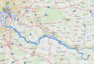
This is your route in Kurviger:
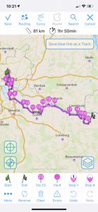
This is your route after import:
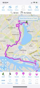
It's mostly the same, except in the city (near the start flag) is where it sometimes takes a different road. This however can be adjusted by adding some via points in Scenic during import:
The reason why this happens and why there is always a chance for these small deviations (strange loops) is that Kurviger and Scenic use a different routing algorithm (a different way to calculate what roads to take between via points). Additionally Scenic does take Kurviger shaping points into account, but then replaces those by its own (mostly more) shaping points (or Via points as Scenic called it). More information on this here: https://scenicapp.space/blog/knowledge-base/strange-loops-while-importing/ (this link is about route import, but it's the same for Kurviger import).
Especially in cities, where there are many options to go from A to B, it's possible that Scenic chooses a different road than Kurviger.
I know this is maybe not the answer you were hoping for, but I hope it at least explains. If not or if you have other questions please let me know. Happy to help.
Best regards and ride safe,
Guido
Hi Maja,
Indeed this route it not a 1:1 copy of the Kurviger route, but when I tried it there was not too much difference to be honest.
This is your route in Kurviger:
This is your route after import:
It's mostly the same, except in the city (near the start flag) is where it sometimes takes a different road. This however can be adjusted by adding some via points in Scenic during import:
The reason why this happens and why there is always a chance for these small deviations (strange loops) is that Kurviger and Scenic use a different routing algorithm (a different way to calculate what roads to take between via points). Additionally Scenic does take Kurviger shaping points into account, but then replaces those by its own (mostly more) shaping points (or Via points as Scenic called it). More information on this here: https://scenicapp.space/blog/knowledge-base/strange-loops-while-importing/ (this link is about route import, but it's the same for Kurviger import).
Especially in cities, where there are many options to go from A to B, it's possible that Scenic chooses a different road than Kurviger.
I know this is maybe not the answer you were hoping for, but I hope it at least explains. If not or if you have other questions please let me know. Happy to help.
Best regards and ride safe,
Guido
Quote from maja on March 31, 2021, 00:56Hello Guido,
thank you for your detailed explanation. You're right, the streets at the beginning are different whereas the route at the end is mostly simliar.
I put a lot of emphasis on working out the route through the city, so this was important for me. The need of reconstructing the route in Scenic makes using Kurviger completely obsolete for me, since I have a lot of work to do in the Scenic app again to correct the route.
Would it be possible for me to export the route as a GPX track and thus import a 1:1 copy into Scenic? Can Scenic route based on a track?
Many thanks, Maja
Hello Guido,
thank you for your detailed explanation. You're right, the streets at the beginning are different whereas the route at the end is mostly simliar.
I put a lot of emphasis on working out the route through the city, so this was important for me. The need of reconstructing the route in Scenic makes using Kurviger completely obsolete for me, since I have a lot of work to do in the Scenic app again to correct the route.
Would it be possible for me to export the route as a GPX track and thus import a 1:1 copy into Scenic? Can Scenic route based on a track?
Many thanks, Maja
Quote from Guido on March 31, 2021, 02:48I understand. Unfortunately because of the different routing algorithms this can’t be solved completely. Although in Scenic 3 ( https://scenicapp.space/blog/knowledge-base/scenic-3-info/ ) the route will match a lot better as Scenic 3 will use a different map and routing engine.
Meanwhile there are a couple of ways to deal with this:
1. In this particular case, add just a few via points. it’s really very easy because the blue dotted line is the exact route from Kurviger (it’s the Kurviger track drawn on the map) so you see exactly where the differences are and can place additional via points. I did this route in under one minute. Here is a link to the route with additional via points: https://scenicapp.space/route/RFRWQPMI (click it to add it to your routes)
2. Do not plan the first part but put the route start point outside the city. You obviously know the roads in this case, so I’m assuming you can find your way to that start point without navigation. If you go for this option, after import, select the route for navigation and then, in the start screen, before tapping ‘Start Ride’, set ‘Guidance to route start’ to ‘none’. Ride tracking will start anyway after tapping the start ride button, but you won’t get turn by turn instructions until you reach the route start point
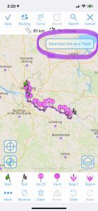
3. Save the blue line as a track. As mentioned in point 1, The blue dotted line you see in Scenic is the exact route (the track if you will) of Kurviger. You can choose to save this line as a track in Scenic using the ‘Save blue line as track’ button:
This has a disadvantage though. Scenic tracks will not give you turn by turn navigation. During the ride the line will be drawn on the map for you to visuallly follow. This function is mostly intended for off-road routes but can be used for any route really. More info here: https://scenicapp.space/blog/knowledge-base/offroad-dual-sport-trail-routes/Hope this explains a bit more and gives you some options.
Cheers,
Guido
I understand. Unfortunately because of the different routing algorithms this can’t be solved completely. Although in Scenic 3 ( https://scenicapp.space/blog/knowledge-base/scenic-3-info/ ) the route will match a lot better as Scenic 3 will use a different map and routing engine.
Meanwhile there are a couple of ways to deal with this:
1. In this particular case, add just a few via points. it’s really very easy because the blue dotted line is the exact route from Kurviger (it’s the Kurviger track drawn on the map) so you see exactly where the differences are and can place additional via points. I did this route in under one minute. Here is a link to the route with additional via points: https://scenicapp.space/route/RFRWQPMI (click it to add it to your routes)
2. Do not plan the first part but put the route start point outside the city. You obviously know the roads in this case, so I’m assuming you can find your way to that start point without navigation. If you go for this option, after import, select the route for navigation and then, in the start screen, before tapping ‘Start Ride’, set ‘Guidance to route start’ to ‘none’. Ride tracking will start anyway after tapping the start ride button, but you won’t get turn by turn instructions until you reach the route start point
3. Save the blue line as a track. As mentioned in point 1, The blue dotted line you see in Scenic is the exact route (the track if you will) of Kurviger. You can choose to save this line as a track in Scenic using the ‘Save blue line as track’ button:
This has a disadvantage though. Scenic tracks will not give you turn by turn navigation. During the ride the line will be drawn on the map for you to visuallly follow. This function is mostly intended for off-road routes but can be used for any route really. More info here: https://scenicapp.space/blog/knowledge-base/offroad-dual-sport-trail-routes/
Hope this explains a bit more and gives you some options.
Cheers,
Guido
Quote from maja on April 1, 2021, 03:02Hello Guido,
thank you very much for answering my questions.
Especially the route through the city is highly complicated (it is an industrial area with several bridges and complex street situations) and that is where I need the navigation the most.
Would'nt it be a useful feature to have at least some basic turn-by-turn directions for gps tracks? Just following a track on the mobile screen is not really an option for this kind of complex routing.
However, I have high hopes for Scenic 3 and looking forward for the new release!
Thanks, Maja
Hello Guido,
thank you very much for answering my questions.
Especially the route through the city is highly complicated (it is an industrial area with several bridges and complex street situations) and that is where I need the navigation the most.
Would'nt it be a useful feature to have at least some basic turn-by-turn directions for gps tracks? Just following a track on the mobile screen is not really an option for this kind of complex routing.
However, I have high hopes for Scenic 3 and looking forward for the new release!
Thanks, Maja
Quote from Guido on April 1, 2021, 03:16Cheers Maja. Understand the question but alas, not so simple as it may seem to make a track navigable. If you’d like to know more detail about why, have a look here: https://scenicapp.space/blog/turn-turn-instructions-gpx-tracks-everything-never-wanted-know/
I believe I gave you some workable options above though. If these are not workable for you, I guess the only thing to do is wait for Scenic 3. Have a good one and all the best,
Guido
Cheers Maja. Understand the question but alas, not so simple as it may seem to make a track navigable. If you’d like to know more detail about why, have a look here: https://scenicapp.space/blog/turn-turn-instructions-gpx-tracks-everything-never-wanted-know/
I believe I gave you some workable options above though. If these are not workable for you, I guess the only thing to do is wait for Scenic 3. Have a good one and all the best,
Guido
Quote from dogboy on April 2, 2021, 10:54If I may chime in, this issue seems to occur most anytime you try to import a GPX route created on one platform to another platform, especially if the route is complex (which is what we motorcyclists usually prefer.) I have the same issue with routes I export from Garmin Basecamp and websites. I have to audit the imported route and always need to make a couple of fixes. Sometimes this involves adding a waypoint, and other times I have to replace a waypoint with a new one because the existing one might be slightly off the road, resulting in a short detour with a U-turn built into it.
Unless every map provider uses exactly the same maps, which is unlikely, I think this is just the cost (and benefit) of having so many sources of routes to ride. Scenic seems to do as well as any when dealing with map mismatches, and at least it's really easy to fix the issues.
If I may chime in, this issue seems to occur most anytime you try to import a GPX route created on one platform to another platform, especially if the route is complex (which is what we motorcyclists usually prefer.) I have the same issue with routes I export from Garmin Basecamp and websites. I have to audit the imported route and always need to make a couple of fixes. Sometimes this involves adding a waypoint, and other times I have to replace a waypoint with a new one because the existing one might be slightly off the road, resulting in a short detour with a U-turn built into it.
Unless every map provider uses exactly the same maps, which is unlikely, I think this is just the cost (and benefit) of having so many sources of routes to ride. Scenic seems to do as well as any when dealing with map mismatches, and at least it's really easy to fix the issues.