
This article reviews the 12 Best Motorcycle Apps for Planning, Navigation and Tracking, available for iPhone in 2017. It focusses primarily on Motorcycle Apps providing features around Ride Planning, Navigating and Tracking, so no loosely related apps like speedometer, google maps, weather apps, motominder, speedtrap or motorcycle games for example. If you think an app is missing add a comment below, but only if it fits the category. This is a new edition of my similar review article of 2 years back,
I do not claim to be totally objective as MotoMappers’ own app Scenic is in the list, but I’m trying to be. I want you, motorcycle rider with an iPhone, to get an overview of all the best motorcycle apps for navigation and tracking out there, so you can make an informed decision on what’s the best app for you. Feel free to comment if you have a different opinion on something I’m saying.

Best Motorcycle Apps for Ride Planning, GPS Navigation and Tracking on iPhone
The Apps Reviewed (in alphabeticle order)
- Best Biking Roads (BBR)
- Diablo Super Biker
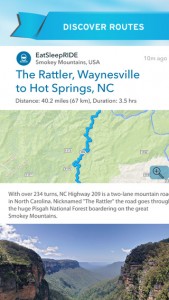
- EatSleepRIDE (ESR)
- GreatestRoad
- InRoute (Not in old article)
- MotoEye
- REALRIDER
- Rever
- Round (Not in old article)
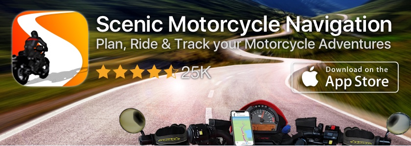
- Scenic (Not in old article)
- TourStart
- WeRide
You’ll find a detailed written review on all these apps below. If you don’t feel like reading, here’s a comparison table against the main criteria important for motorcycle navigation:
| App Store Rating | Creating Routes | Importing Routes | Navigation | |
|---|---|---|---|---|
| Best Biking Roads | N.A. | |||
| Diablo Super Biker | N.A. | N.A. | N.A. | |
| Eat Sleep Ride | N.A. | N.A. | N.A. | |
| Greatest Road | N.A. | |||
| InRoute | ||||
| MotoEye | N.A. | N.A. | N.A. | |
| RealRider | N.A. | N.A. | N.A. | |
| Rever | ||||
| Round | N.A. | N.A. | ||
| Scenic | ||||
| TourStart | N.A. | N.A. | ||
| WeRide | N.A. |
| Finding Routes | Ride Tracking | Offline Maps | |
|---|---|---|---|
| Best Biking Roads | N.A. | N.A. | |
| Diablo Super Biker | N.A. | N.A. | |
| Eat Sleep Ride | N.A. | ||
| Greatest Road | N.A. | N.A. | |
| InRoute | N.A. | N.A. | N.A. |
| MotoEye | N.A. | ||
| RealRider | N.A. | N.A. | |
| Rever | |||
| Round | N.A. | ||
| Scenic | |||
| TourStart | |||
| WeRide | N.A. |
Again. These are my personal ratings based on personal preference and what I find important for an app on the Best Motorcycle Apps list. You might rate things differently. Therefore I encourage you to read the full review below and download some of these apps and give them a try. Most of them are free to download.
Best Biking Roads (BBR)
![]()
Since the old article BBR added 2 new significant features: If you find a nice route you’d like to ride, you can download/export the gpx file of that route directly from the app. They also added a feature that lets you find motorcycle rental points and biker friendly accommodations. For the rest it looks and feels pretty much the same.
BBR was probably one of the first Motorcycle Centered websites focussing on Routes specifically for Motorcycle Riding. They started with their website and later added the App. They currently have about 32k users (from 30k 2 years back), 13k routes (from 8k) and 13k route reviews (from 12k). Routes have a detailed description, some of them with pictures. They can be created on the website or can be uploaded to the website through GPX upload. The website route creator is pretty basic and wasn’t changed in the last 2 years. It lets you drop pins and that’s about it. You can’t undo or add intermediate points so if you make a mistake you’ll have to start over. The upload works well, although I did get an error message after uploading, but when I went back the route was uploaded successfully.
 The App lets you search routes in their database by location, rating, country and some more options. At first you’ll get a list of the routes you searched for including rating, length and distance from current location. You also have the option to show them on a map.
As mentioned above the app now also let’s you export the route. Navigation is not a feature. The app also has a Route Creation feature which is better than the one on the website as if offers an undo feature.
 The main plus point for Best Biking Roads is the active community which ensures a large number of high quality routes and route reviews. I have no doubt that you’ll always be able to find a route to your liking with BBR. Although it doesn’t navigate It’s earned its place in this list of Best Motorcycle Apps!
Price: $3.99
Advertising: No
In App Purchases: No
App Store Rating:
Diablo Super Biker
![]()
Diablo Super Biker was updated a couple of times, but these were mostly bugfixes and feature enhancements. No significant new features were added. Diablo Super Biker is an App specialized in measuring your performance during riding. It not only can measure your performance on the road, but also has a special track option that measures you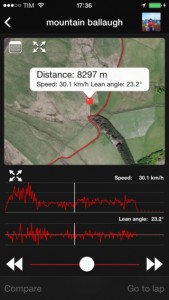 r lap performance when riding on a race track. It’s a pure Tracking App. It doesn’t offer routes or navigation.
What’s very nice about the app it that it records your lean angle during the ride and shows this in a nice graph over the duration of your ride. And, of course it’s very nice that it’s remains free. It’s not available in all countries though.
Because it offers nice tracking features it’s in this list of Best Motorcycle Apps.
Price: Free
Advertising: No
In App Purchases: No
App Store Rating:
EatSleepRIDE (ESR)
![]()
ESR is updated on a regular basis. So, since the old article they added quite some new little features and changed the look and feel a bit. They also added an Apple Watch App for ride recording. Most importantly they added a function on their website (not their app) to export GPX files of your rides. For the rest it’s pretty much the same as described in the old article.
ESR is a good looking app and packs a lot of features. It’s been out there for a while and shows up in most ‘Best Motorcycle Apps’ lists. Because it’s so packed with features it takes a while to get used to the user interface and realize just how much it can do. The focus of ESR is more towards the social aspect of riding. It has kinda like a small Facebook for 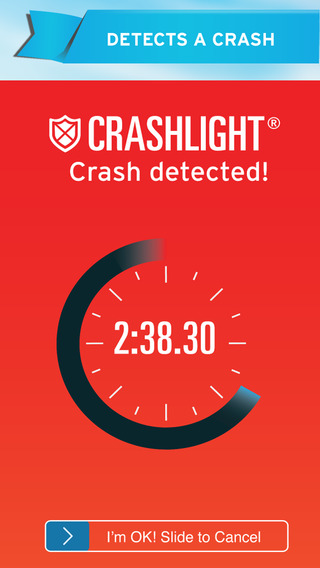 Motorcyclists integrated if you will. You can post stories, places, pictures, reviews, routes, events etc. to the ESR news stream and those posts can also be shared to the main social channels like Facebook, Twitter, Google+ and even WhatsApp.
It can also track your rides and help you organize group rides with fellow ESR users. The tracker not only tracks your location, distance, speed and duration, but also elevation and, similar to Diablo Super Biker, lean angle. And of course you can share those rides in the same way as mentioned above.
 Next to that ESR offers CRASHLIGHT (in app purchase), which is a security feature that sends your info and location to three of your closest contacts if your phone detects that you crashed. (You have the option to cancel this within three minutes in case you didn’t crash but just dropped your phone or something.) Since the old article they upgraded to CRASHLIGHT 2.0.
Needless to say that ESR is one of the most feature packed apps in this list. Only thing that would make it even more complete is the ability to create or import and navigate routes.
Price: Free (was $0.99)
Advertising: No
In App Purchases: CRASHLIGHT $14.99/year (was $9.99/year)
App Store Rating:
Greatest Road

Greatest Road was not updated since july 1st, 2015, so it’s 100% the same as described in my old article. Here’s what I wrote back then:
Greatest Road is probably the most well known Motorcycle App out there, perhaps together with Best Biking Roads. It nearly always shows up in the “Best Motorcycle Apps” lists that are already out there. The basics are actually quite similar to BBR, however it has more features and in my opinion it’s more advanced. It doesn’t have a website like BBR does though.
The route finding feature is very similar to Scenic’s. It lets you search for routes by selecting a map area  and then it will load all the tracks for that area and show them on the map. By tapping on a route it will show you more details about it and you can open a new screen showing you even more details, including a description and ratings.
Greatest Road doesn’t do ride tracking and can’t navigate you along routes, but it does offer a very interesting feature. It will let you open the selected route in a third party navigation app. For example, I know that it supports opening a route in Navigon (for details on how Navigon than deals with this look at my other blog post here). I don’t know of any other apps it supports as it only shows the Navigon option if you have Navigon installed, so if you know of another supported app please leave a comment below. Alternatively, if you don’t have Navigon installed, it can open Google Maps for you and Google Maps will guide you to the route start point. Unfortunately Google Maps doesn’t support multi point routes at the moment so once you arrive at the route start point you’re on your own. If that still doesn’t work for you the app can also send out an email with a link to the GPX file of the route.
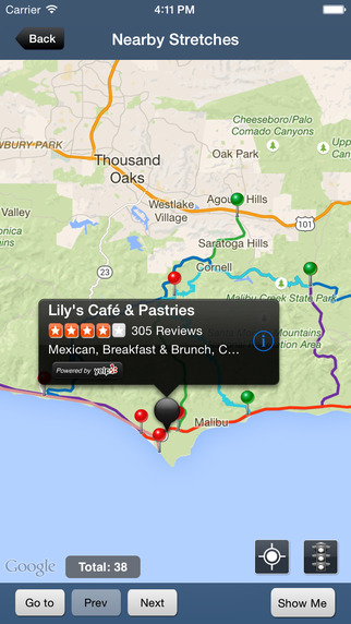 About a year back Greatest Road also integrated Yelp into the App, which lets you find restaurants, hotels and other amenities along the route or in a certain area. A nice feature if you’re looking for a place to stay or a restaurant for a lunch break during your rides.
With Greatest Road you can create routes quite nicely. It shows a crosshair center screen and you then postion the map so that the location you want to add is in the crosshair. You then tap “start”, “waypoint” or “end” and it will drop a corresponding pin there. If you made a mistake you can just tap on a pin and you’ll be able to delete it from the route
Price: Free
Advertising: Shows one fullscreen Ad at each startup
In App Purchases: No
App Store Rating:
InRoute

InRoute does not advertise as an app specifically for motorcycle riders, however it’s fairly well known in the community because of the features it offers. In short, it offers route planning and navigation. The UI takes a little getting used to, but once you are used to it you’ll soon find that InRoute is very feature rich. It has a relatively simple looking (but again, feature rich) built in turn by turn navigation and, like Greates Roads, also offers the opportunity to navigate routes with 3rd party apps, like Navigon.
Like mentioned, the built in navigation looks simple, but it’s really not. It includes traffic information, offers the ability to skip waypoints and can show a graph with elevation, curviness or weather information along your ride. Very nice. For motorcycle riding I would argue that the font sizes used are too small (except for the next instruction text) to let you quickly glance and have a good idea on where/when to turn. There are no ‘arrows’ showing the next turn, but in stead it shows a small section of the map.
The route planner is also very feature rich. You can tap and hold on the map to add your start, waypoints and destination. You can also rearrange those points in a list view. Furthermore it offers a lot of routing options, amongst others “Most Curvy and “Least Curvy”. I have not tested this in real life, so I don’t know how good this “Curvy” routing is for motorcycle riding. Please leave a comment if you have experience with it. Last but not least it also has POI support along your route, so you can plan a gasoline stop or hotel-stay along your route.
InRoute also offers Route Import (GPX, KML and XLSX) and route export to GPX. The GPX Import is a bit strange though. I tried to import a GPX that contained a route with 183 points and 2 tracks with more points. I got the message that it could not import the route as it had over 100 route points, so it only imported the 3 waypoints, ignoring the tracks all together. Then I tried to import a GPX with only 1 track (with thousands of points), no routes and no waypoints. This actually worked. It ‘filtered’ the trackpoints down to 99 and then calculated a route between the filtered points. This is also how Scenic works, although Scenic can go up to 200 points. It’s a bit strange that InRoute doesn’t show you the GPX elements and doesn’t let you pick which ones you’d like to import. It makes this choice for you it seems.
 All in all InRoute is a very nice and complete app. It’s not advertised as being specific for motorcycle riding, and, my honest opinion is, that this is with reason. It doesn’t track your rides, but most importantly the built in navigation is not suited for quickly glancing to your phone on the handlebars to find your way. The route planner however is probably the most complete of all apps in this list. The whole package makes it a worthy app in the Best Motorcycle Apps list.
Price: Free
Advertising: No
In App Purchases: $4.49/month or $33.99/year
App Store Rating:
MotoEye
![]()
Since my review 2 years ago MotoEye had one update that didn’t include any significant new features. It’s basically the same as it was when I wrote the old article. It’s mainly a Ride Tracker but has some nice additional features. Similar to Scenic you can take pictures during your ride and they will be added to your ride in the activities log. Unlike Scenic though, you can also record videos and add them to your ride. Looking at the app’s  background story this is one of the reasons that MotoEye came to be. To make video recordings while riding and record your route at the same time.
Another nice feature is that it has a weather report included. It shows the current weather, the weather in 2 hours and tomorrow. Nice if you’re not sure to bring your rain overall. Further you can add the bikes you have (no pictures) to your “garage” and, very nice, it has Offline Maps, for free!! How’s that for Best Motorcycle Apps list.
 It also offers turn by turn and voice navigation, but only to a specific destination, not for routes. You enter a destination and it will guide you there while tracking your ride. In their update notes they mention ‘External navigation always use Apple Maps’. I was not able to discover what they mean by this. I couldn’t find a feature/button or something like that in the app.
Price: Free
Adversiting: No
In App Purchases: No
App Store Rating: N.A. Insufficient ratings to determine
REALRIDER

REALRIDER is an App mainly intended for users in the UK as it is integrated with the NHS Control Room Network. It has a similar function as ESR’s CRASHLIGHT called REALSafe, but it doesn’t contact 3 of your closest contacts, it directly contacts the Ambulance Service (also here you have a small amount of time to cancel this if you didn’t crash). It’s updated on a regular bases. A significant feature update since the previous article is the Nearby feature, which lets you explore routes and places around you. Next to REALSafe and Nearby it also is a Ride Tracker.
 Does this app belong in the Best Motorcycle Apps list? For the REALSafe feature I would say definitely so. But, if you feel differently, leave a comment.
Price: Free
Advertising: No
In App Purchases: No, but you do need a £3.99 /month (was £25 / year) subscription for REALSafe (only available in UK)
App Store Rating:
Rever
![]()
The most stand-out feature for Rever is that they’ve integrated Butler Motorcycle Maps into the app (in app purchase). For those unfamiliar with Butler: their Motorcycle Routes are of high quality and are scouted by a team of “scouts” riding around. They have routes for a lot of US States, unfortunately not outside of the US, yet? 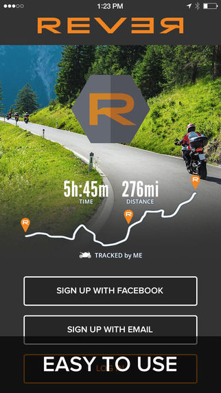
Since the previous article Rever was updated regularly. You’ll also find it in most Best Motorcycle Apps list out there. The most standout added features are satellite and terrain views and ride sharing. Next to that they changed the UI somewhat. As before you can create your own routes on their website, after which they will show up in the app under the “Rides” tab. In the app, you then just select a route to follow it. The route following is ‘follow the line’, so no turn by turn and voice guidance. They draw the route on the map and you just “Follow the line” while your ride is being tracked.
A bit strange is the difference between Butler routes and the routes made by you or other riders. The butler routes show up as marked roads on the map (with 4 separate colors indicating “coolness” of the road). This is pretty handy when you’re riding around. See a yellow marked road, TAKE IT. I haven’t found a way in the app to get more info on those roads like a description or pictures though. Perhaps I missed something. Please let me know if I did.
 The routes you created or others created don’t show up on the map, so you can’t find them by viewing a map area. You’ll have to select them from the list of rides and select them specifically before starting your ride. After selecting a specific route that route will show on the map and you can start following it.
You can also become friends with other Rever users and friends can share routes amongst each other. Another nice feature is that you can “Ride with Friends”. It’s a bit similar to Apple’s Find my Friends, but specifically tuned to Other Rever users. You’ll see their position along the route on the map. If you don’t want that you can turn that feature off.
With Rever you don’t need an internet connection when you’re going out for a ride. Just select a ride from the rides tab and tap “Offline”. Rever will download the map data for that route and you’re good to go. Again, this only goes for your own routes or public/friend’s routes. Not the butler roads. My guess is that the idea behind this is that you can plan a route yourself (on the rever website) which can include a butler road, because the map planner also can show the butler roads, similar to the app.
Price: Free
Advertising: No
In App Purchases: Premium membership ($5.99/month or 59.99/year)
App Store Rating:
Round

Round is not advertised as an app specific for motorcycle riding, however it does show up in the ‘Users Also Bought’ section of the app store if you search for a motorcycle app. Round is a beautifully designed app. Really, it’s beautiful. Functionality wise it’s currently a bit limited from a motorcycle app perspective. In short, it offers navigation and basic tracking, but no route creation nor import or export.
Ride tracking is very similar to Scenic ride tracking, although more basic. You can track your rides by simply tapping a button. Once you’re done with your ride it will ask you to enter a name and description for the route and you’ll get the option to make this route public. If you do, other users can find this route and navigate it too. Different than Scenic, you can only track your ride if you are NOT navigating a route. So you can’t track all your riding adventures. Seems the purpose of tracking is for route generation only. The tracked information is also very basic. Only your coordinates are tracked. No speed profile, nor ability to add pictures. Navigation itself is again, beautiful and simple and includes voice guidance.
I’d love to see this beautiful app add more features to it to make it more complete for Motorcycle riding. Does it belong in the Best Motorcycle Apps list? Maybe not now, but I hope the developers will consider expanding it more.
Price: Free
Advertising: No
In App Purchases: No
App Store Rating:
Scenic

Scenic is my own app, so I’ll try and be as objective as possible. Together with InRoute, Scenic is the only app that can import Routes and make them navigable. Scenic currently only offers GPX import (unlike InRoute which also offers KML and XLSX). However Scenic also offers other handy ways to get routes in the app. There is a web app that lets you paste an URL from a route you created with Google Maps and Scenic integrates with several online route planners (currently Furkot and RouteYou).
The route creation i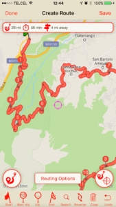 n Scenic is very similar to the Greatest Road route planner. Intuitive and easy to use. You can add, move and delete via points. There’s an ‘undo’ button and a
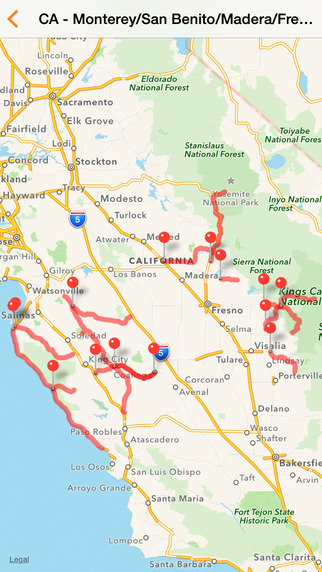
‘reverse route’ button. Once you create a route or import one you’ll be asked if you want to make it public. If you do other users will be able to navigate it, review it and add pictures to it. Until now this has resulted in a database of 3k Scenic routes.
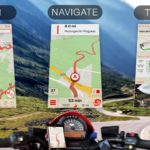
The navigation looks very much like the standard navigation apps (e.g. Google Maps or Apple Maps), with the main difference that Scenic can navigate you along routes of up to 200 via points. Next to this it offers advanced features for when you take a detour (deliberately or not). By default it will guide you to the first via point you missed, but you can also choose to skip that via point and connect with the route on one of the via points further down the road. Navigation can be online, or you can download offline maps so you won’t use any data from your plan.
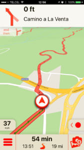 While you are navigating (or just riding free without navigation), Scenic tracks your ride. It tracks your location, your speed and you can add pictures along the way. After you’ve finished your ride, similar to Round, you’ll be asked to enter a name and description to the trip. Afterwards you can go back to your trip list and remember your riding adventures. You can also create a route from previous trips so you can ride them again and/or share them with others.
Of course you can question my objectivity for this app, but the user ratings don’t lie. Give it a try yourself and you’ll see why Scenic definitely earns a place in the Best Motorcycle Apps list.
Price: Free
Advertisig: No
In App Purchases: Premium ($10.99/year or $49.99 once) Offline Maps (around $25 for a continent, downloadable by country or state)
App Store Rating:
TourStart
![]()
TourStart is a Route Creator, Route finder and Route Navigator first and foremost. It won’t track your rides as such, but it saves your rides as tours so you can ride the same route again. Specific info like avg speed or max speed of a ride is not stored.
Like ESR the user interface is not standard iOS, it takes some getting used to. The start screen is quite nice and gives an overview of what the app can do. You can Plan a Route, Find tours uploaded by others, Plan or find an event and put it’s location on the map and navigate routes.
The route planner is more or less similar to the route planner of Greatest Roads and Scenic, so good and easy to use. Finding routes is also done by a map view, like Scenic and Greatest Road. On higher zoom levels it shows one marker with a number in it, indicating the number of routes and/or POIs in that area. When you zoom in further the one marker becomes more markers, indicating a route start point or a POI. If you tap the lowest level marker a callout appears and you can tap the callout to see more details. That will bring up either the POI description with an optional picture or, if it was a route, the route map, a list of waypoints and optionally a description and pictures for the route. 
As for the turn by turn and voice instructions, I’ve not had a chance to test it out extensively, but from my first tests on short routes I would say it is good. If you have experiences with TourStart’s Navigation feature I would love to hear about it. Please leave a comment below. All and all, TourStart is a very complete and well thought through app once you get used to the UI.
I’m not sure why TourStart is not mentioned a lot in the existing “Best Motorcycle Apps” lists. Please share your experiences with this app in the comments and help me understand!
Price: Free
Advertising: No
In App Purchase: Navigation ($14.99 / year)
App Store Rating: N.A. Insufficient ratings to determine
WeRide
![]()
WeRide, not to be confused with the skating app WeRide, is a nice Motorcycle App that’s been out there a couple of years now. It’s used a lot in the Spanish speaking countries which I guess is logical because it’s developed in Spain. It’s also available in English and a couple of other languages though.
WeRide’s user interface is basic/simple, but in a good way. Due to it’s simplicity it’s fairly intuitive to use.  That’s not to say that the app is simple, it’s actually extensive and hides a lot of good and well thought through features. Since the previous article they added a route export feature which lets you export your routes to GPX, KML or directly open it in Apple Maps.
WeRide’s main focus is social. The app is also listed in the Social Networking category. You can become friends with other users, but that’s not all. You can create or join groups and post things to the “wall” of the group or socialize on the group forum. Besides that WeRide also has a chat function to chat directly with your WeRide friends. There are quite a lot of groups. You can find them on the map (they have a location) but also by searching by country/city and/or riding type (Road/Trail/Offroad).
Similar to BBR you can find routes nearby or by country and filter by riding type and distance. Unfortunately it’s not possible to find routes on the map, so you’ll have to go into the details of a route to see the map.
The Route Creation in WeRide is pretty similar to the one in Greatest Road, Tourstart and Scenic, so again, good and easy to use. Once you’ve choses or created a route you can also navigate it. The navigation is “Follow the Line” like  Rever’s and while you navigate your ride is being tracked too. Similar to TourStart your ride is not being saved as a ride as such, it’s saved as another Route and like Rever, the information saved with it is pretty basic: distance, time, description, type and a picture. No information that’s specific to you for that ride, like avg speed, max speed, pictures along the way.
They also have a WeRide shop where you can purchase motorcycle gear, however when I tried this I got an “unexpected error”. Maybe that’s due to my location (Mexico)? I don’t know.
Price: Free
Advertising: No
In App Purchases: No
App Store Rating:
Conclusion
Well. This was a long read, and if you’ve come all the way to the bottom of this I appreciate your time and reading through all of it. By now you probably know there can not really be a number one in the Best Motorcycle Apps list. Some apps are better in one thing, while others are better at another thing. Some apps are missing this feature, while others lack another feature. In the end it depends what you want from an app. I designed Scenic to be an app alternative for the expensive motorcycle GPS units out there. Although not perfect yet, I think it’s pretty close, and I’ll keep at it, adding new features and improvements.
Feel free to leave comments below!
Hey everyone!
There’s also a great app called Wolfpack (www.wolfpack.run) that reinvents the group riding experience by making it easy to plan your ride and invite friends, as well as navigate, communicate and keep track of the riding group using a radar system.
Watch this quick video for more info. https://www.youtube.com/watch?v=USqQCAPJ8Nw
Then download Wolfpack by clicking this link if you’d like: onelink.to/9kmw37
Ride safe!
Thanks. Doesnit work with mobile metwork or does it wotk from satellites? We ride in Africa and mobile signals are weak and often non existent so we really are looking for something that work with satellites and IOS.
Hi Dries,
Yes it works on satellites only. Just make sure you download all the offline map regions that you need while you are still on wifi.
Cheers,
Guido
sas scenic os IOS only, seems beyond silly to lock out over half the country.
I understand your comment. You are not the first one saying this :-). Reason why no android yet: I’m an independent iOS developer, working alone, without backing from investors. Building and maintaining an app on two platforms costs time and money. Scenic is doing well, however I can’t live from it yet, let alone invest in an android version (I have to hire someone for it). I’m thinking about doing a Kickstarter campaign to make the android version. That will tell me how much interest there really is and, if fully funded, give me the financial means to make this happen. Hope you understand.
Thanks Guido.
I hope you’re able to get the funding and support you need for an Android version. I’d really like to try your app, but I boycott iOS handhelds. lol
Apple = The Evil Empire (also synonymous with the New York Yankees)
Apple vs Google ? I’ve learned not to argue anymore haha.
Android by end of 2020.
I get the whole single developer issue. If you get a droid version going will check it out for sure
I use ESR and Scenic, and so far, I much prefer Scenic. I do like the social aspect of ESR and being able to track mileage and stuff, but as a navigation tool, I find Scenic to be my preferred app. Great job, Guido.
Well done Guido ??
One suggestion; perhaps you can interact with most popular riding groups in countries for them to share best riding routes per region. In return for good riding routes , you may share some data or statistics with them which they may benefit
Thanks for the suggestion Mehmet. Scenic already integrates with Route Planning sites (Furkot and RouteYou), but currently you can only see the routes you created yourself on there. I will look into this a bit more and see if I can find more route providers willing to share their data.
Since I typically only rely on a GPS when I’m touring, I haven’t had much opportunity (yet) to really dig into Scenic. I just started playing around with it last Fall, so I’m looking forward to really digging in this coming Summer. I must say, Scenic is the nicest app I’ve tried thus far (I have used Sygic, InRoute, CoPilot, Google Maps, Waze, and one or two others whose names I don’t really remember). As a rider of backroads, I learned early on that I need offline maps — online maps are of little value if you’re out of the range of a cell tower.
I also do all of my trip planning on Furkot (a tremendous online trip planner). I LOVE that Scenic EASILY integrates with Furkot. That, for me, is worth the cost of Scenic (and then some). And, yes, it’s TRULY EASY!
Keep up the great work, Guido!
Thanks Craig!
Hi,
First of all, thanks for the reviews, very handy.
Just a little comment, i wanted to try out your app so i clicked the Scenic icon in the article, but it’s linked to Rever in the iTunes store.
Normally I wouldn’t take the time to inform the author of the article for such a small thing, but since it’s your own app I thought you would like to know 😉
Will try your app out now, looking forward to using it.
Cheers,
Sebastiaan, Belgium
UPDATE:
Clicked on the link on your homepage but apparently it’s not available in the Belgian iTunes store.
Too bad though… I will try one of the others, but interested to know if you would make it available in Belgium too.
Cheers,
Sebastiaan, Belgium
It’s (very) temporary not available. I removed it from sale because the latest version contained a critical bug.
A new version is currently awaiting Apple approval. Once that’s approved (today or tomorrow I hope) I will let you know.
Apologies for the inconvenience and regards,
Guido
Should be available again now: https://itunes.apple.com/app/id1089668246
TX. Will update asap.
This review is written by the author of one of the apps. It fails the most basic test for objectivity.
The review does not mention app stability. Sure an app may have dozens of features, but what good is that if the app crashes all the time? Guess which app would fare poorly if this were factored into the equation?
Thanks for letting me know. I’ve had other reports already about the crasheS. First of all I want you to know that this is (still) my highest priority. Unfortunately I can’t tell you when it will be 100% fixed as it’s not an easy reproducible problem. The crashes are random: they don’t occur for everyone all the time (see below why).
I do have some suggestions. These have helped other users reduce the crashes or prevent them all together.
1. Before you start Scenic close all other apps you don’t need anymore (double tap home button and swipe up all apps)
2. Put ‘Get Map Data Online’ to ‘No’ in Scenic settings -> Map (you would need the offline map for your area if you do that)
3. Once every few weeks: close all apps (double tap home button and swipe up all apps) and really turn-off your iPhone (by holding the on/off button for at least 5 seconds). Wait 10 seconds and then turn it on again. That will basically reset the memory. Although it shouldn’t happen, some apps (even Apple’s own apps) leave residual memory-allocations which then can not be allocated to apps anymore. Regardless of Scenic, this is a good practice anyway.
If you’re interested why these suggestions help… it’s because the crashes occur because your iPhone is running low on memory. If that happens iOS starts to kill apps, starting with the app that uses the most memory (which is often Scenic). iOS won’t kill foreground apps at first… it starts with backgrounded apps (which explains the crashes seem to occur more often when Scenic is in the background and/or iPhone is locked). By doing steps 1 and 3 you free up memory and with step 2 you reduce the memory usage of Scenic.
I hope these suggestions will help for you. In the mean time I will continue to analyse and try and reduce Scenic’s memory footprint. Also I’m in contact with Scenic’s map provider on how the map framework (which accounts for 85% of Scenics memory usages) can reduce their memory footprint.
Hope this explains a bit more. If you have any follow up questions please let me know.
Best regards,
Guido
I know everyone’s preferences differ, I just want a motorcycle navigation app that runs on my iPhone and gives good verbal instructions through earphones. I’ve used Maps successfully in this way, but want to be able to choose my route rather than have it chosen for me. Sometimes selecting a simple curvy or scenic route is enough, other times I’d like to choose more specifically.
But the deal maker/breaker for me is the voice instructions, which your article and score chart don’t seem to mention. Does that mean they’re all much the same in that respect?
Great article btw.
Jon.
Hi Jon. Thanks for the (very) good question. Voice instructions are not the same for all these apps. Those apps without turn-by-turn navigation obviously don’t have voice instructions, but for those that do there can be some differences: E.g. differences when (distance before a turn) you hear instructions, mentioning street names and/or numbers, the clarity/quality of the voice etc. Honestly I didn’t test this for all these apps so I recommend just giving them a try (and share your experiences here ?)
What I know is that it also depends greatly on the region and area you are riding. If you’re riding in the country side with only a few roads and relatively simple intersections most of these apps will do just fine. However if you’re in an urban area with more complex intersections and a lot of roads, the differences might surface and, for me, in thos urban regions, I just like to see the map also just to verify and get more detail if required. I live in Mexico City, Mexico and use Waze on a day to day basis because of the good traffic information. I consider Waze to be one of the best A to B mainstream navigation apps, but even with Waze, inside this crazy city, I need to see the map in order to avoid taking the wrong turn.
Hope this helps a bit.
I’m with you Jon. I find google maps will stop working once I hit my first viapoint, unless I dig my phone out and tell it to continue. Worse, it sometimes reroutes me to its selected route vs. my custom
Is the scenic it also available for Android?
Hi Franz. Not yet and it’s going to be a while I think. Maybe I will do a Kickstarter campaign to make the android version. That will tell me how much interest there really is and, if fully funded, give me the financial means to make this happen. Hope you understand.
ok thanks for the ananswar. The app looks great.
Hi I have a friend who downloaded your app, but was disappointed since you do not have interface in French. Maybe a translation into a couple of major languages would help get new users.
Currently Scenic is available in English, German, Spanish and Dutch. More languages will follow in the future. French is top of the list.
Awww…. was really bummed out when I found that you didn’t have Scenic on Android. I’ve tried several apps, but so far none really work for me. If I plan out a ride in Google Maps, I can add multiple stops. For Father’s Day, the wife and I are going to do a ride (no kids, ha ha) from home to a Harley store we haven’t visited, then to a specific BBQ place in East Texas, then two more HD shops. But no app so far really works for me doing this. Rever was close, but broke it up into multiple “rides”.
Thanks for the comment. I’m looking into an Android version currently. But it’s going to be a while like mentioned below. You could try GPSVisualizer.com (convert file at the top) to turn the Google Maps URL into a GPX. Then maybe some Android apps can handle it.
Interesting article thx. However I didn’t see Osmand app in your list
OSMAnd is very limited on iOS. On iOS, it’s not really a player in the motorcycle navigation area as far as I know. I’ve heard that Android version has a lot more features.
I have not heard of most of these apps. but they seem to focus on the US I think.
I have been using Copilot on an ipad mini for a couple of years and find it very good. A motorcycle preference with an option to avoid or favour road types has resulted in some excellent rides throughout Europe. The maps are offline so no problem with signal or wifi. Changing routes for personal preference is reasonably easy and if a deviation from the route is chosen then the response is quite quick and the original route picked up. The timing of delivery of info. such as turns etc. can be selected. No tracking of rides and it seems that routes have to be planned in Copilot so convenience of using the larger screen of a Mac is not there.
I started off reading the on screen map and directions (big enough on an ipad) but once I tried the voice commands I have found that there is little need to look at the screen. It can also work as a live map so with no route planned you can see where you are.
I hope this is useful.
How many waypoints can I load into scenic? I have a route with around 350 ‘turning points’, all on private land, can scenic handle this?
Scenic can handle thousands of waypoints. The private land might be a problem though… if it’s really private land the roads might not be mapped and if the roads are not mapped a route calculation will not be possible. You can give it a try if you want. Scenic is free to download and you can free credits to try out the premium features (like route import).
Getting Strong Desire to do endurance riding – starting green but experienced in achievement. Putting together my tools for success, and must say your Scenic/Furkot initially gets my attention – so in advance I can say thanks.
What functionality is available without the in-app purchase in Scenic?
You can find this and more info on in app purchases here: http://www.motomappers.com/faqs/faqs.php#whyIAP
Hi Guido,
I’m stuck between your app and inRoute. The only thing I really need is importing GPX files and providing turn-by-turn. inRoute does this for free while yours is ~$50. Unfortunately, I can’t justify the cost of a slightly better-looking app. If you decide to reduce the price to $10, I’d jump on it in a heartbeat.
Thanks,
Kyle
Hi Kyle,
I have to disappoint unfortunately. I can’t financially justify reducing the price at this moment. I truly believe Scenic has some significant added functionality and advantages over InRoute. Of course this depends highly on what you are looking for in an app (and I’m biased in my view obviously). I totally understand if you’d prefer to go with InRoute. Please note however that Scenic does give you free credits to try out the premium features. That should help make a really good comparison between Scenic and InRoute, before you make your final decision. Also note that you don’t have to get Premium Forever. There are other options available like the yearly subscription or ‘pay as you go’ through credits. More info on that here: http://www.motomappers.com/faqs/faqs.php#whyIAP.
Cheers,
Guido
Does Scenic account for dirt roads? I’m planning a trip to some rural areas and if possible I’d like to avoid gravel/dirt roads.
Hi Brian,
Scenic doesn’t have an ‘avoid unpaved’ setting. I recommend trying Kurviger.de to plan your route. They do have this setting. And they integrate with Scenic to send your route from their website to Scenic: https://docs.kurviger.de/app/ios/import_route_into_scenic_app
Hope this helps/explains. If not or if you have other questions please let me know. Happy to help.
Cheers,
Guido
One of the best combinations I have found for planning and tracking is using Tyre to Travel (http://www.tyretotravel.com) to plan and Pocket Earth (https://pocketearth.com) to track. I plan my route on Tyre on a small laptop I have connected to Dropbox. Then I export the route to a GPX file in Dropbox. I go to iPhone and upload the GPX from Dropbox into Pocket Earth which uses satellite antenna so no roaming charges and lower battery usage. Keep phone in heads-up waterproof mount charging on handlebars. Can bring small laptop for changing route on long rides.
Is there a function for finding “curvy roads” in any of those apps?
Question I currently use either google maps or mapquest however I am planing a trip next year. Is there a GPS navigation app that has fuel stops. So The feature would be find gas station with in the route every x amount of miles.
As far as I know there I no app that does this at the moment. I will add this to Scenic 2 in the future.
It’s currently awaiting Apple Approval.
Here’s a video that one of the beta testers made, so you’ll get an idea of what to expect: https://youtu.be/ck2IzI3txlI
In our newsletter ‘Moto Intel Report’ I report on progress of the big update.. Here you can see past editions and subscribe if you’d like: https://scenicapp.space/blog/category/moto-intel-report-newsletter/.
Hope this helps/explains. If not or if you have other questions please let me know. Happy to help.
Best Regards,
Guido