
Routes vs Tracks and ‘Save blue line as a Track’ during import
Routes vs Tracks in a GPX file
When importing from a GPX file often times the GPX file will contain a route and a track for the same journey. What’s the difference exactly?
- Typically a ROUTE is a plan for an upcoming trip. It contains a start point, an end point and possibly a few stops that you’re planning to pass. When you feed those points to a navigation app (like Scenic), it will calculate which roads to take between these points, based on the routing mode that you choose (fast/short/efficient, avoiding highways, avoiding toll roads, etc.) and that apps route calculation algorithm. Different navigation apps use different map data and different route calculation algorithms. This means that, for example, TomTom might calculate a different route than Scenic and Google Maps might give you yet another route. Mostly however, the algorithms and data are pretty close and you’ll end up with the same route, but not always.
- Typically a TRACK is a record of a passed trip. It also contains the start and the end point, but in between, it contains a lot more points. In fact it usually contains hundreds or even thousands of points: a point (a GPS coordinate) every few meters/feet as it was recorded/logged during a ride that you did. In that sense it’s much more precise than a route.
The bullets above start with the word ‘Typically’ because a track can also be provided for a planned trip (i.e. it’s not a record of a passed trip). In that case the track contains points along the route as it was calculated by the app/program/GPS unit that generated the GPX file. For example, if you export a GPX with a track from Garmin Basecamp, the track will contain points along the route as it was calculated by the Garmin map data and route algorithm.
Importing Routes vs Tracks in Scenic
Scenic can import both routes and tracks.
If you import a route Scenic will use its own Route Calculation algorithm and the Routing mode you set to calculate which roads to take between the points. This means that sometimes the route can be different as it was intended by the person who designed the route, because that person was using a different program (i.e. a different map source and route calculation algorithm) and/or using a different routing mode (routing modes are not stored in GPX files).
If you import a track Scenic will try to make a route out of it. It does this by reducing the many, sometimes thousands, of points in the track in a smart way and feeding those reduced points to the Scenic route calculation algorithm. Usually this works pretty good. In other words, usually the route that scenic calculates with these reduced points, follows the exact track. Sometimes however, there are differences, like in the example below.
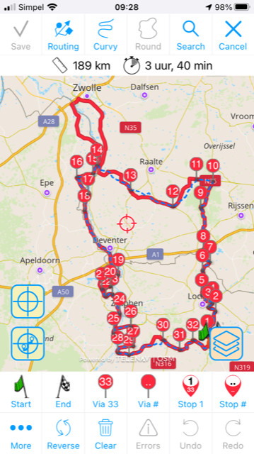
Scenic makes these difference clear by drawing the original track as a blue dotted line, and the calculated route as the red line (by default it’s magenta). Mostly these differences can easily be corrected by moving, deleting or adding some via points. Why these difference occur and how they can be corrected is explained here.
Sometimes however, these difference can not be corrected. There are some workarounds for those situations (mentioned here), but sometimes it’s better to save the blue line as a track. Many times this is because the track follows small dirt roads that are unknown to Scenic, or Scenic does know those small roads, but thinks you are not allowed to go there. This is where the ‘save blue line as track’ button comes in. For those cases you can choose to save the blue line as a (Scenic) track.
Disadvantage of ‘Save blue line as a Track’
Saving the blue line (the original track from the GPX) as a track in Scenic has a disadvantage. Routes (the magenta/red line) have turn by turn and voice instructions during navigation. Tracks (the blue line during import) have ‘follow the line’ navigation only. This means that the line is drawn on the map for you to visually follow. You will NOT see turn instructions at the top of the screen (i.e. big arrow with the next turn and text stating ‘in 300 feet turn right’) and you will NOT hear voice instructions for tracks at all.
Should you import the Route or the Track if you have both?
If you have both, it’s recommended to import the Track. This will give the biggest chance of getting the route exactly as it was intended by the creator. BUT… it’s important that you check that the magenta/route line follows the blue dotted line… and make corrections where necessary by moving/deleting/adding via points. To thoroughly check this it’s recommend to zoom in on the route a bit and follow the route by dragging the map.. and notice any differences between the red/magenta line and the blue line.